

Map of Lagoa Santa
Where the town is, how it is laid out, and what is close to what.
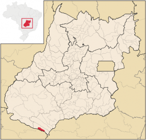
Lagoa Santa lies at the southernmost point of the state of Goiás, Brazil, right on the border with Mato Grosso do Sul, which is drawn by the Rio Aporé. On a map of the state, look below Rio Verde and Quirinópolis, next to Itajá. The town itself is small and flat: the hot-spring lagoon, the river, the hotels and the shops are all a few minutes' walk from one another.
Interactive map
Open in Google Maps Get directions to Lagoa Santa
Advertisement
Location within the state of Goiás
Landmarks
| Place | Where it is |
|---|---|
| Thermas Lagoa Santa (hot-spring lagoon) | GO-302 highway, Km 19 |
| Balneário Kin Gin | R. João Inácio, town center |
| Rio Aporé | Southern edge of town; the guesthouses on Av. Ulisses Guimarães sit on the riverbank |
| Lago Municipal Clarito Pereira Campos (municipal lake) | Urban area; home of the fishing tournaments |
| City Hall | R. Valdomiro Teodoro Rios, town center |
| Bus station | Town center · (64) 3648-1439 (from abroad: +55 64 3648-1439) |
| Emergency hospital (Hospital de Pronto Socorro) | Town center · (64) 3640-1267 |
| District of São João do Aporé | On the riverbank, with guesthouses and fishermen's houses |
Coordinates
Latitude 19°10′55″ S, longitude 51°23′01″ W (−19.1819, −51.3836). Elevation of the town: 380 m. Use these coordinates in GPS apps in case the name gets confused with Lagoa Santa (MG), in the metropolitan area of Belo Horizonte, which is a different town altogether.